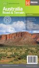
Hema Australia Handy Map 11th Edition

The Australia Handy Map is a foldable, compact Australian map that is perfect as a journey planner or reference tool.
- 11th Edition
- Shows national parks and major road networks
- Shows major city CBD maps
- Distance chart and place name index for practical use


It shows national parks and major road networks with distances for planning, along with major city CBD maps for Brisbane, Melbourne, Sydney, Canberra, Darwin, Adelaide, Perth and Hobart on the reverse side, as well as a distance chart and a placename index for practical use.
Key Features
- Hema's iconic map of Australia
- Capital city maps
- National parks
- Road distances
- Indigenous lands
- Distance grid
- Fully indexed
Scale: 1:6,500,000
Folded size (WxHxD): 125mm x 250mm x 3mm
Flat size (WxH): 625mm x 750mm
Weight: 0.06kgs
Pick Up
Unfortunately we currently do not offer customer pick ups
How much does shipping cost?
Shipping is a flat fee of $9.95, there may occasionally be an extra freight charge if items purchased are heavy, bulky or being delivered to a regional or remote location, but we will notify you via email if this occurs
How long will Shipping Take?
Metro Areas
Usually between 1-7 business days since time of order
Rural Areas
Rural areas can take anywhere between 1-10 business days depending on where you are located